Where the rivers Ribble and Darwen meet at Walton Flats is the Capitol Centre, a large modern retail park. What most shoppers don’t realise is that this site was once a Roman military supply depot and distribution hub, picked for its excellent access to the rest of the Lancashire region. Excavations have shown that the Roman road that connected Wigan to Lancaster travels under the car parks, and crossed the Ribble close to where the large stone arched bridge carrying the A6 is today.

The Roman site at Walton-le-Dale housed workshops for potters and blacksmiths. Silver and lead were also being refined on site. Goods from abroad were being brought here by boat for redistribution. Imports included Roman Samian ware (a thin, red pot, often with elaborate designs), oil in large amphora (jars) and possibly wine too. Other goods included glass and jewellery (such as a copper alloy brooch found during excavations). Two parts of the modern retail park have been excavated and we shall look at them both in turn.
The excavated site south of Winery Lane, near the gym

To see the first site which is south of Winery Lane, park at the car park in front of the Virgin Active Gym. At the far edge of the car park by the grass verge and hedge is a wooden sign, with very faded writing on, barely readable today. This historical information sign gives details about the Roman site and also marks the spot where a potter’s kiln from the era was excavated. With your back to the gym, imagine a line running from the nearby road bridge (seen over the hedge), past the information sign and proceeding through the gym. This was the line of the Roman road, and there were buildings laid out along it.
Starting in the middle of the second century, this area was the site of metal working forges, probably making knives and other blades. A circular building found here could mean that the smiths were Britons working under the supervision of the Romans. Later in the second century, buildings described by archaeologists as ‘beam-in-slot’ were built here. Various interpretations for their use have been given, perhaps they were stables or warehouses for storing goods brought in by boat. A collection of mortaria (Roman kitchen ware pottery) dates from this time, so perhaps this was being stored and then distributed from here. These buildings were later replaced by a different type, the style of which archaeologists call ‘post-in-hole’.
Around 260-300 AD a circular pottery kiln was constructed here. The kilns were very similar to those found at Wilderspool in Warrington and could even have been made by the same potters relocating to this site. Excavation evidence shows that the potters were making roof tiles.
The excavated site north of Winery Lane, near the Park and Ride

To reach the second excavated site we must cross over Winery Lane. Leave the first site by the gym and walk past the cinema and bowling alley until you reach the corner of Capitol Way by the Waitrose store. Turn left and head down Capitol Way until you reach the crossroads with Winery Lane. Cross straight over the crossroads and head for the ‘Park and Ride’ area. Keep the Thrifty car rental on your left, and walk towards the entrance to the Park and Ride. Stand by the blue height barrier for the car park and turn to look over in the direction to the rear of the Virgin Active Gym. You should just be able to make out its roof in the distance. The grassy fenced area between the gym and the Thrifty rental car park is the second site that was excavated. (Better views of it can be seen if you head up to the banks of the Ribble behind you, which we will do shortly.)
The second excavated site was first occupied between 117-138 AD. Large ‘beam-in-slot’ buildings were laid out either side of the Roman road. Between each building was a cobbled access area. All these buildings had both water supplies and a hearth, but what their purpose was is still speculative. Suggestions have included brewing and leather working, but also food preparation and even large laundries. When a fire destroyed all the buildings they were immediately replaced, and the previous activity resumed. Further rebuilding occurred throughout the Roman occupation with all the buildings later being replaced with ‘post-in-hole’ style ones. Even more remodelling and rebuilding occurred in the third century before the site was abandoned in the early fourth century.

To see where the Roman road crossed through our second site, head out of the Park and Ride area towards the banks of the Ribble. There is a path up to the top of the bank which you need to climb. Once here, turn your back on the river and look over the Park and Ride area to the rear of the gym for a better view of the second excavated area. You can clearly see a grassy area, behind a large metal fence.

Follow the path along the bank in the direction of the large stone road bridge that carries the A6 over the river. Shallow draft Roman boats would easily have been able to come from the sea up the Ribble to dock here and unload goods. Stop when you come alongside the large aerial in the modern goods yard over on your right. The path of the Roman road through our second site would be through the gym (which you can just about make out the roof of) and to the right of the aerial, up to where you are standing now.
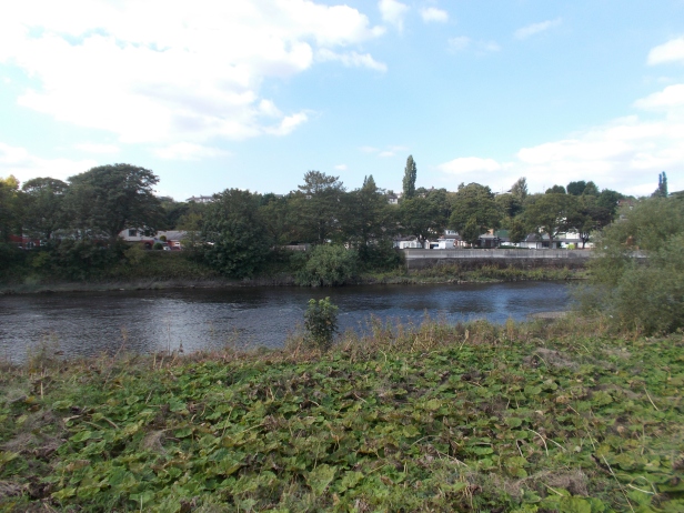
If you turn around and look across the Ribble, it was around here that the road crossed, presumably on a Roman bridge, and went north up the hill on its way to Lancaster (see photograph above).
Both the two excavated sites show that all the manufacturing activity was gradually wound down, with an organized withdrawal leaving only waste material behind. No tools or useful stocks of raw materials have been found, showing that these were removed in an orderly, careful way.
The site at Walton-le-Dale was probably under control of the military. There are at least a couple of reasons to think this. The first is that the buildings are laid out in a regular manner, a hallmark of the Roman army. The second reason is that silver working found on the site was always an ‘Imperial monopoly’ and hence would be controlled by the army. Although the military controlled the site, it was not a fort and no defensive ditches have ever been found.
The real key to the site is its location. Two rivers meeting, one of which has access to the sea, made it ideal for moving supplies around. The road north ended up at Lancaster’s fort and to the south it reached the fort at Wigan. To the east was the fort at Ribchester and it is known that supplies from there were sent up to Hadrian’s Wall. Supplies could be carried by boat from Walton-le-Dale using the Ribble to reach Ribchester. The road connecting Ribchester to the fort at Kirkham lies just a short distance north of Walton-le-Dale.
There is a saying that a ‘good site is a good site’, meaning that a site is used over and over again throughout history. This is certainly true of Walton Flats, but the Romans were not the first to make use of it. Both of the two archaeological sites we have discussed also had a lot of stone age flints found on them, from both the Mesolithic and Neolithic. Long before the Romans arrived, people would have camped here, knapping flints for hunting the animals that came to drink at the edges of the two rivers.
Site visited by A. and S. Bowden 2014
Parking: The site is one big car park, along with shops. Parking is free.
Nearby, just a short walk away
St Leonard’s Church, Walton-le-Dale
The Strange Tale of Edward Kelley at Walton-le-Dale
Nearby, just a short distance by car:
Preston’s Lost Medieval Friary
The Lost Leper Hospital of St Mary Magdalene,
References
Roman North West England: Hinterland or ‘Indian Country’ ? Tom Saunders (Editor),(2011), Council for British Archaeology North West . (The archaeological information for this blog post is taken from the chapter in this volume authored by Peter Iles. The site is a very complex one, and the full archaeological report is yet to be published.)

Comments are closed.